Oh, I thought “the house was on fire”? Yet, cold is the absence of warmth.. Watch out North! Manitoba is going to be hit
Weather Network
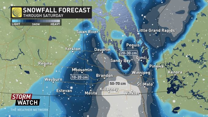
Winter storm watches and warnings blanket southern Manitoba, including Winnipeg, as a potent stateside system targets the province with heavy snow and dangerous blizzard conditions. The province already saw some heavy, wet snow and ramping-up winds Thursday, but the worst of the storm is still to come Friday, with unsettled conditions expected to linger right into the Thanksgiving long weekend ahead. More on the timing of this system and just how much snow this system threatens, below.
A "potentially historic" storm will batter the north-central United States over the next few days with some parts seeing "moderate to heavy snow" and record low temperatures, according to various weather agencies.As of Thursday morning, the storm had already dumped some snow on certain parts of Montana, Wyoming and Colorado. Forecasters said there was already a report of 24 inches of snow in Pony, Montana. The Park County Sheriff's Office in Livingston, Montana, posted photos on its Facebook page of a snow-covered interstate and asked motorists to drive safely. Police in Denver issued the same message to drivers after they received 96 traffic crash reports in the span of three hours.
There have been hundreds of flights delayed at Denver International Airport and at least 100 flights cancelled according to FlightAware.The National Weather Service said "moderate to heavy snow" is expected for the southeast part of the state into parts of the Central and Northern Plains. The snow will be accompanied by gusty winds which could make traveling difficult.The agency called the tempest a "significant, and potentially historic, October winter storm."
A significant, and potentially historic, October winter storm is on track to impact the northern Rockies, and areas of the central and northern Plains through Saturday. Significant travel disruptions, power outages, and impacts to agriculture and livestock are all anticipated. pic.twitter.com/5KGdPOfWJQ— NWS WPC (@NWSWPC) October 10, 2019
Weather forecasters said the storm is expected to linger over the Northern Plains into the weekend, with 6 to 12 inches of snow predicted for the region and isolated totals up to 18 inches from Bismarck, North Dakota, to Fargo. Weather.com warned that "dangerous blizzard conditions" are expected in the region through to late this week.
The snowstorm will arrive in the Canadian Rockies late on Monday and push into the northern Rockies of the United States throughout Tuesday, but it will not stop there.The National Weather Service has posted winter storm watches for parts of the Northern Plains states, with more warnings and advisories expected in the days ahead as the winter weather sweeps much further south.By Wednesday, any rain over the Northern Plains and High Plains will turn to wet snow from parts of Montana into Wyoming and the western Dakotas.Cold air plunging in with the storm will allow snow to accumulate and travel conditions to deteriorate, not only in the highest elevations but also in the valleys.The heaviest snow is expected over higher ground in Montana, Wyoming and Colorado, with at least 15 centimetres (six inches) also possible in the central and western Dakotas.Denver and Cheyenne in Wyoming will both see their first snow of the season and it could well be several centimetres.Temperatures will plummet as the cold air and snow arrive, with Billings in Montana going from a high of approximately 21 degrees Celsius (69.8 degrees Fahrenheit) on Tuesday to below freezing as the snow falls during the night.
Cold is the absence of warmth.
From earlier today: