Cold IS the Absence of Warmth. We had one day. Just one. Yesterday. That was an absolute glorious spring day. I’ve not seen so many people out and about in such a long time. It was great! Unfortunately, the cold that persisted through April looks to be set to stay in May.Geofish also covered his horrid for us gardeners and everyone else news!
Record Cold May Coming Up
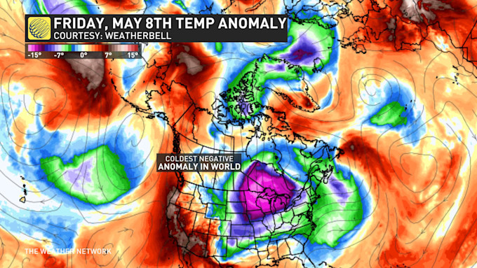
Monday, May 4th 2020, 7:28 am - There is high confidence that Ontario will see temperatures well below seasonal since some of the most extreme temperature anomalies on Earth will soon move into this region.Hot on the heels of our first 20°C of the season for many communities across Canada, the chilliest air relative to normal around the globe is set to swirl across Ontario by Friday.
The patch of purple below shows temperatures nearly 20 degrees below seasonal aloft, and no other anomaly around the world will come close to this on Friday.More recently, the atmosphere has featured much more mid-latitude blocking, which are the weather patterns that disrupt the typical westerly flow. The mid-latitude blocking will be the trigger that will send this extreme temperature anomaly on a collision course with Ontario.For those yearning for balmy spring temperatures, unfortunately I can confirm that there is high confidence in the forecast for these below seasonal temperatures in Ontario. The magnitude of the cold air is also looking to be an exceptional outlier, much like the cold air mass that the region saw in April.
POTENTIAL FOR RECORD-BREAKING COLD
Back on April 22nd, a Buffalo weather balloon captured a profoundly cold late-season trough and recorded -20°C at 3000 metres elevation, which is the latest on record. But here's the thing. We might just break that late-season record, twice in one year – this time in May.Just how cold can a daily high temperature be in May? It varies across much of Ontario.
MAY SNOW THREAT
Snowfall isn't exceptionally unusual in northern Ontario in May, but it is quite extraordinary for parts of southern Ontario.
Toronto (YYZ) typically accumulates a few centimetres of May snowfall every couple of decades since the beginning of the climate record, but it was notably more common in the 1960s and 1970s.
Of course, we should all keep in mind that in the '60's and '70's we were supposed to be heading for an ice age. And the last snowfall in May, hubby and I can recall was most likely in the late 70's. On a May 24 week end. But by and large most memories of that holiday week end were of heat. Except for the past ten to twelve years....
This year’s snowfall threat will ramp up by Thursday for northern Ontario and by Friday for southern Ontario. It will also spill into the weekend with continuous threats of snow and rounds of graupel across the Great Lakes Basin.
Oh, yaaah! Not.Recalling a cold April and not looking forward to a cold May- well below "seasonal norms"