by Jim Johnstone and Judith Curry
Climate Forecast Applications Network (CFAN) has identified new early precursors for seasonal Atlantic hurricane activity that involve systematic, repeating interactions among ENSO, stratospheric circulations and regional North Atlantic processes.
Introduction
Forecasts in December for next year’s Atlantic hurricane activity are desirable for writing insurance and reinsurance contracts. However, providers of seasonal hurricane forecasts — notably Colorado State University (CSU) and Tropical Storm Risk (TSR) – have judged seasonal forecasts this far in advance to have little to no skill.
After providing December forecasts for many years, in recent years CSU has only issued qualitative guidance, with multiple scenarios primarily based on possible scenarios of the strength of the Atlantic Multidecal Oscillation and whether or not an El Nino forms.
Tropical Storm Risk’s Extended Range Forecast for 2018 Atlantic Hurricanes states: “TSR predicts Atlantic hurricane activity in 2018 will be slightly above the long-term norm and close to the last 10-year norm. However, the uncertainties associated with this outlook are large and the forecast skill at this extended range is historically low.” TSR’s main predictor at this extended lead is the forecast July-September trade wind speed over the Caribbean Sea and tropical North Atlantic. The factors underpinning this forecast are sea surface temperatures in the North Atlantic and extended-range ENSO (El Nino-Southern Oscillation) predictions.
North Atlantic hurricanes show sensitivity to regional climate anomalies, in particular, those related to tropical ENSO conditions and North Atlantic sea surface temperatures (SSTs). Positive anomalies of North Atlantic Accumulated Cyclone Energy (ACE) and US hurricane landfalls (Fig. 1) typically occur with cool eastern Pacific La Niña conditions and warm surface waters over the tropical and broader North Atlantic.
Figure 1. Annual time series of North Atlantic Accumulated Cyclone Energy (ACE) and US hurricane landfall totals, 1995-2017.
Tropical SSTs display considerable monthly persistence, facilitating probabilistic forecasts of late summer hurricane activity from spring-summer SST anomalies and tendencies. However, ENSO and North Atlantic SSTs exhibit little memory of prior conditions at leads of 6 months and longer, providing only very limited information about hurricane activity several seasons ahead. Because the springtime ENSO ‘predictability barrier,’ the ENSO state during late summer and autumn typically has little relationship to peak anomalies during the previous winter, limiting the skill of primary ENSO and SST-based forecasting methods of late summer hurricane activity to lead times no greater than one season.
Research conducted by CFAN in spring 2017 identified regular Arctic hurricane precursors at ~6 month leads that successfully foreshadowed twice the normal level of US hurricane landfalls in 2017. Our latest research has developed tools that push the envelope of hurricane predictability out to leads of 12 to 24 months.
Extended-range predictability analysis
To assess whether there is any predictability of Atlantic hurricane activity at extended lead times, CFAN undertook a comprehensive climate dynamics analysis to identify extended-range precursors to the seasonal Atlantic hurricane activity.
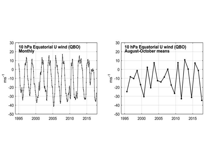
Large-scale climate modes, including ENSO, are generally thought to evolve through stochastic, largely unpredictable processes that present a fundamental barrier to long-range forecasting. A potential exception is the stratospheric Quasi-Biennial Oscillation (QBO), a semi-regular ~28 month oscillation of equatorial zonal winds that has (Fig. 2) attracted the attention of forecasters since its discovery in the 1950s. Strong, systematic effects of the QBO upon surface climate have proven elusive, however, and recent irregularities demand caution in the application of historical QBO relationships to future climate anomalies. Figure 2. Monthly and late-summer (August-October) seasonal means of zonal winds in the equatorial stratosphere at 10 hPa.
Lagged correlations between QBO and hurricane indices (Fig. 3) reach marginally significant levels (p~ 0.05, |r|~0.4) with the QBO leading by 18 to 36 months, suggesting the possibility of a direct physical relationship between tropical North Atlantic cyclone activity and the circulation of the tropical stratosphere.
Figure 3. Lagged correlations between hurricane indices and equatorial stratospheric winds, representing the Quasi-biennial Oscillation (QBO) at stratospheric levels from 10 to 70 hPa.
Our analysis of global tropospheric dynamics identifies an intriguing spike in global hurricane precursors at quasi-biennial leads of 24 to 26 months (Fig. 4). In this window, patterns of global tropospheric circulation show considerably stronger connections to delayed hurricane activity than those at much shorter leads, and form the basis for our current 2018 ACE and US landfall forecasts.
Figure 4. Relative strength of global tropospheric precursors to North Atlantic and US hurricane activity. The hurricane season is indicated by the shaded bar at month 9 (August-October), while the strength of precursor patterns are illustrated by the magnitude of marker sizes at leads beginning two years earlier (-24 months = December, 33 months previous). Red rectangles highlight a prominent peak in predictability 24 to 26 months before the North Atlantic hurricane season.
A physical explanation for hurricane predictability at quasi-biennial leads can be explained in part by relationships that we have identified among the QBO, ENSO and hurricane-favorable atmospheric anomalies over the tropical North Atlantic and Caribbean Sea.
While QBO relationships to ENSO and tropospheric surface climate are generally considered weak or irregular, we find strong systematic relationships that support the viability of long-lead forecasts of North Atlantic hurricane activity at leads of up to two years. Fig. 5 shows spring relationships among the QBO, ENSO and atmospheric sea-level pressure (SLP) over the Caribbean Sea. Spring QBO changes display strong connections to simultaneous ENSO changes during the spring ENSO predictability barrier. Positive spring QBO changes are similarly related to hurricane-favorable spring SLP declines over the Caribbean Sea.
Figure 5. Spring relationships among the QBO, ENSO and atmospheric sea-level pressure over the Caribbean Sea. A. Positive relationship (r = 0.75) between spring (February-June) tendencies in the 70 hPa QBO and ENSO (Nino 3.4 SST). Spring QBO changes (B) display strong connections to simultaneous ENSO changes during the spring predictability barrier. C. Positive spring QBO changes are similarly related to hurricane-favorable spring SLP declines over the Caribbean Sea.
Forecast model and 2018 forecast
Our extended-range forecast model of seasonal Atlantic hurricane activity is based upon the tropospheric circulation index that we have developed, based upon the preceding predictability analysis. In developing our forecast model, we consider only the period since 1995, which is the positive phase of the Atlantic Multidecadal Oscillation (AMO) that is associated with elevated Atlantic hurricane activity.
As shown in Fig. 6, the forecast model has moderate predictive skill of US landfall totals and North Atlantic ACE two years later. High levels of activity are accurately indicated for the years of 1995, 2004, 2005, 2011 and most recently in 2017. Low levels of activity are indicated during multiyear hurricane ‘droughts’ of 2000-2002 and 2013-15. Long-lead tropospheric indicators generally capture low-frequency aspects of interannual hurricane variability, capturing periods of active and inactive years, but typically underestimate the amplitudes of specific annual anomalies.
Figure 6. Hurricane forecast indices for 1995-2018, based on antecedent anomalies in the global troposphere, 24 months prior. Both indices suggest near-average hurricane conditions in 2018, relative to the active period since 1995.
Forecasts for 2018 seasonal Atlantic hurricane activity, based on global tropospheric patterns at -24 months, suggest ACE total of 132 (+/-50) and 1.7 (+/-1.1) US landfalls, indicating conditions that closely match the 1995-2017 means of 133 and 1.7.
Relative to NOAA’s hurricane season classifications, an above normal season is defined as an ACE index above 111, and an extremely active season is defined as ACE above 152. Our forecast predicts 80% probability of an above normal season, and a 90% probability of 1-2 U.S. landfalls. The predicted values of ACE and # of U.S. landfalls are near the average for the active period since 1995.
Examination of Figure 6 shows 3 years during the period since 2018 (2015, 2006, 2007) where the model predicts ‘above normal’ (ACE>111) and ACE was observed to be below 100. Examination of all years with ACE>150 shows that the modeled ACE was greater than 111 for all years except for 2010.
Confidence in our prediction for 2018 can be derived from our hindcast predictions back to 1995 and the physical plausibility of the model predictors based on our predictability analysis. However, the small sample size since 1995 (which is driven by the regime of the Atlantic Multidecadal Oscillation) limits the confidence that can be placed in the prediction model.
Weather/climate research in the private sector
My company CFAN has a research team of Ph.D. atmospheric scientists that is comparable in size the Webster/Curry research group at Georgia Tech circa 10 years ago. The CFAN research team is focused on developing better weather and climate predications, at timescales from days to decades, to support decision making for businesses.
CFAN has been fortunate to have received 3 Small Business Innovation Research (SBIR) grants from government agencies (DOD, DOE, NOAA); we are near the end of our current NOAA grant on sub seasonal climate predictions (3-6 weeks). Working on a SBIR grant shares some features in common with a university grant — however, the emphasis is not so much on publications, but rather on commercialization of the research.
While the SBIR grants are very helpful, relevant opportunities for such grants are rather infrequent. Hence CFAN conducts a substantial of research that is either funded in the context of client contracts, or from ‘overhead.’ All of our clients are interested in better probabilistic forecasts of future weather and climate, particularly extreme events (e.g. heat waves, hurricanes, etc).
We’ve decided to invest in research on seasonal to interannual climate predictability and prediction, with the hope that fundamental climate dynamics research can provide the basis for better statistical forecasts (observationally based) and statistical-dynamical forecasts (integrating climate dynamics with the numerical seasonal forecast models). Also with the hope that businesses will find these forecasts useful (so we can actually cover our research and forecast expenses!)
Some remarks on how private sector research differs from university research:
- there is no particular advantage to publishing your research in peer reviewed journals; in fact, there is a commercial disincentive to providing enough information publicly for others to reproduce your research.
- the timescales for results and actual forecasts are much faster (timescale of months), rather than the typical 3 year cycle of government grant funding that university researchers operate under
- private sector researchers whose results are applied to predictions are held accountable by their clients — too many failed forecasts with inadequate portrayals of uncertainty, and you will lose your business. This gives researchers a healthy appreciation of model and forecast uncertainty (something that is sorely lacking in the AGW climate prediction community).
- the concept of ‘conflict of interest’ in research becomes pretty meaningless; of course your research and operations are funded by companies who are interested in making money (they are very unlikely to make money from failed forecasts).
But . . .’peer review.’ Evaluation by our clients (e.g. whether they gain or lose money from our forecasts) is far more stringent than the inbred pal review that academic journal publications are subject to.
At the same time, given our long heritage in university research and my more recent efforts in the public communication of science, I am publishing some of our research in the ‘journal’ of Climate Etc., and plan to start a CFAN Technical Report series that is available online.
CFAN’s business model of spending a very large portion of our income on research and development (at the expense e.g. of sales and marketing) may not be particularly lucrative in the short term (I need to figure out ways to increase finding). However it is an exhilarating and liberating model for doing research that is relevant to real world decision making.
Basically, we are liberated from the ‘gamesmanship’ of high impact academic research associated with journal publications, endless writing of grant proposals, and attendingendless conferences, workshops and committee meetings that are needed so that you get sufficient recognition and your research interests are on the funding agenda.