by Rud Istvan
Aitken et. al. in Nature newly comports to confirm 2015 fears about instability of the Totten Glacier in Eastern Antarctica. This could ‘suddenly’ raise sea level as much as 4 meters! (Or, based on the abstract, maybe only 0.9 meters in ‘modern scale configuration’, but over 2 meters [2.9-4] in unspecified other configurations).
There are two parts to the story of Aitken et. al. 2016: the author’s comments as reported by MSM, and what the paper actually found.
Media reports
An example from the Weather Channel:
“An Antarctic glacier three-fourths the size of Texas continues to melt into the sea, and if it disappears completely, sea levels will rise dramatically around the world, a new study says. The Totten Glacier is melting quickly in eastern Antarctica and threatens to become yet another point of concern as global temperatures rise, according to the study published in the journal Nature. It’s getting close to a “tipping point,” the study found, and if the glacier collapses, global sea levels could rise nearly 10 feet…”I predict that before the end of the century the great global cities of our planet near the sea will have two- or three-meter (6.5 to 10 feet) high sea defenses all around them,” study author Martin Siegert told the French Press Agency.” [Bolds mine]
From Science Daily, drawn from the Imperial College London press release:
Current rates of climate change could trigger instability in a major Antarctic glacier, ultimately leading to more than 2m of sea-level rise. By studying the history of Totten’s advances and retreats, researchers have discovered that if climate change continues unabated, the glacier could cross a critical threshold within the next century, entering an irreversible period of very rapid retreat. This would cause it to withdraw up to 300 kilometres inland in the following centuries and release vast quantities of water, contributing up to 2.9 metres to global sea-level rise. [Bolds mine]
Finally, the lurid title of Chris Mooney’s article in the WaPo on May 18: ‘Fundamentally unstable’: Scientists confirm their fears about East Antarctica’s biggest glacier
Paper
Most of the paper is a complex analysis of detailed gravimetric and magnetic data captured from low pass aircraft mapping an important ridge component of Totten’s subglacial geology.
It is helpful to understand the context for seeking evidence of alarming seal level rise (SLR) (see my previous CE post Sea Level Rise Tipping Points). SLR is not accelerating, so warmunists have searched for future ice sheet ‘tipping points’ that might cause the abrupt SLR supporting urgent CO2 mitigation. Greenland was the initial focus; it is not cooperating because of its bowl shaped geology. See my previous post for details and references.
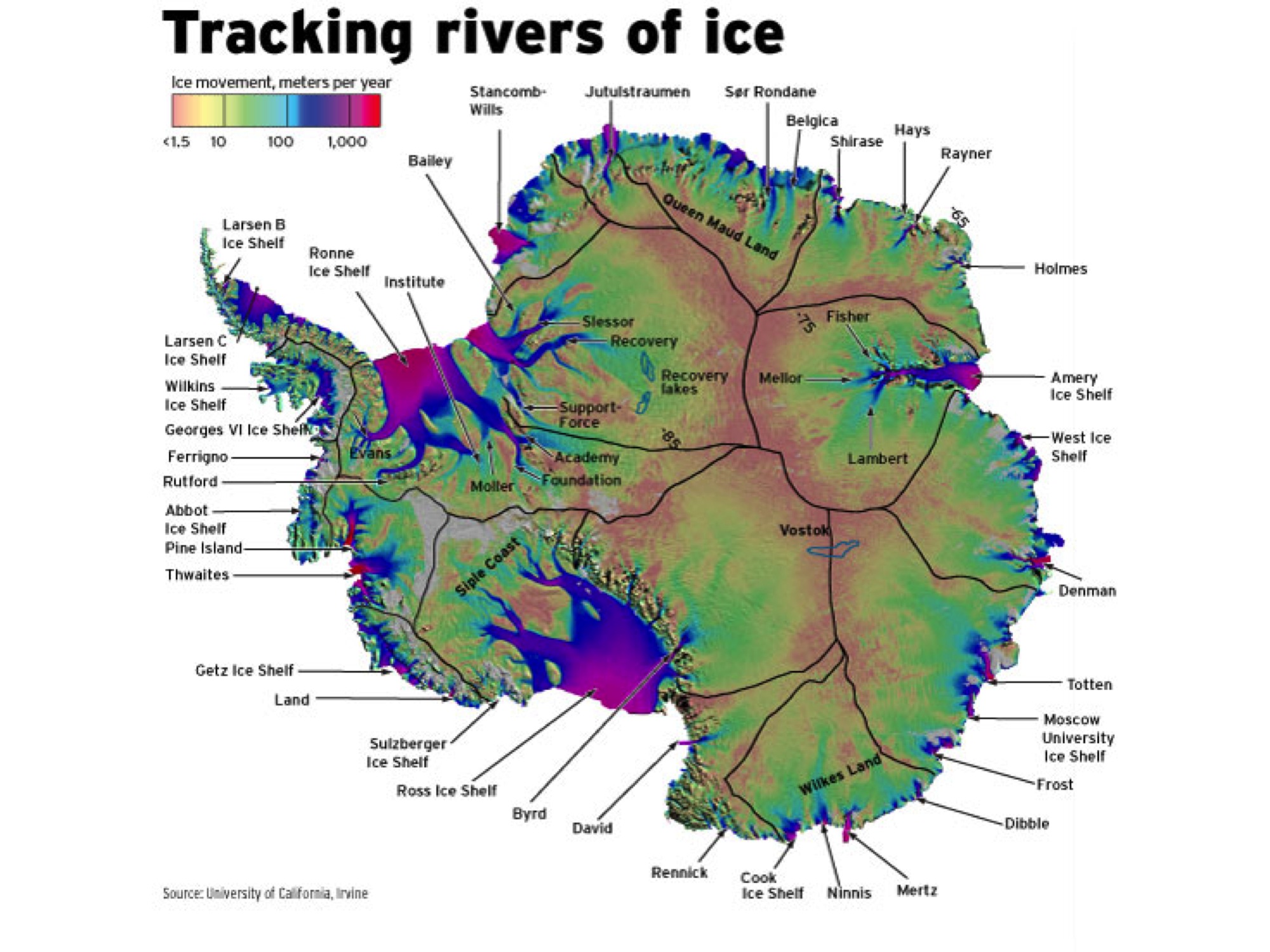
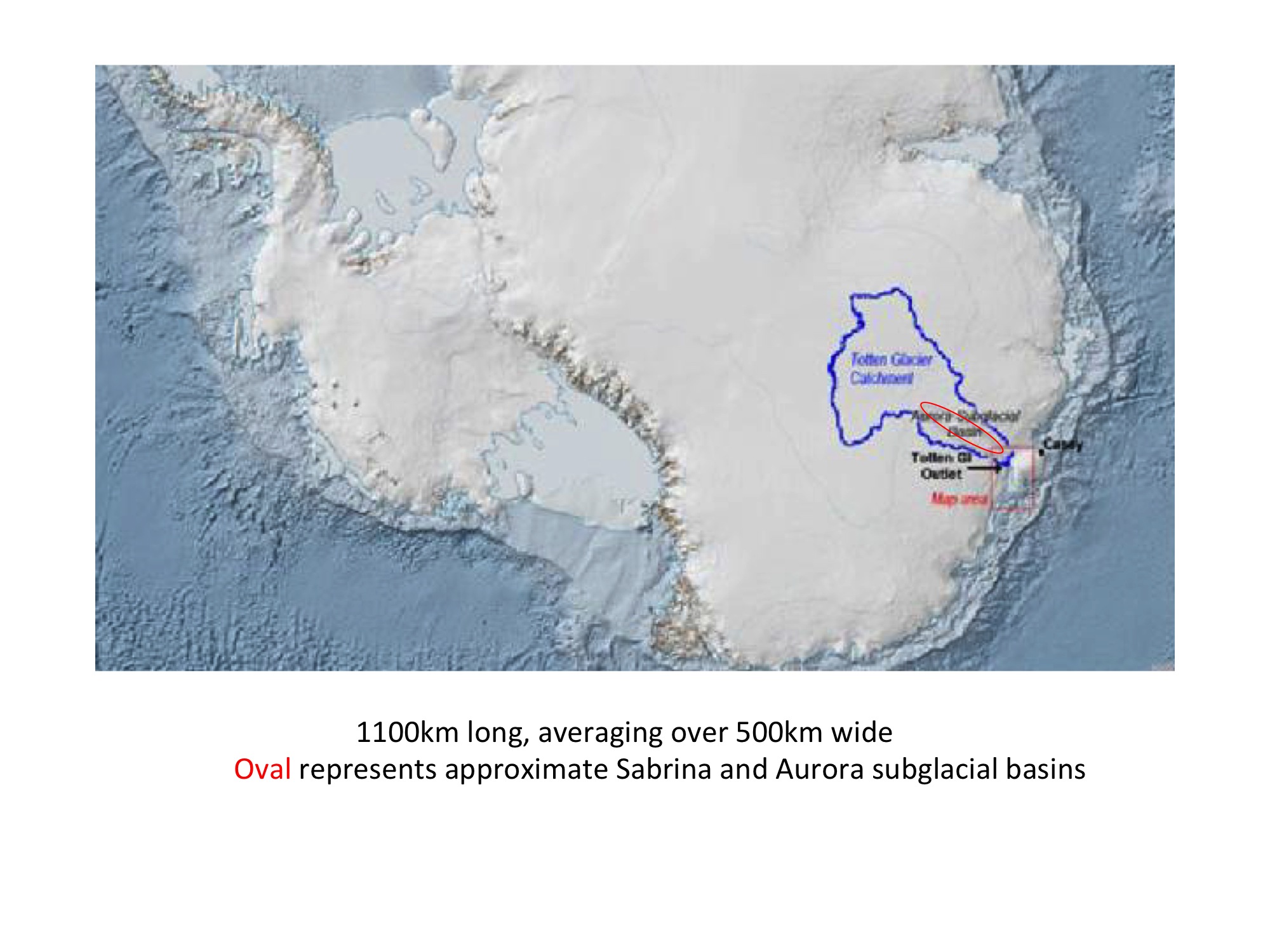
The West Antarctic Ice Sheet (WAIS) was the next focal point. The Ronne Ice Shelf proved pinned and stable per the above linked Tipping Points guest post. ANDRILL showed that the Ross Ice Shelf is also stable; its grounding line hasn’t shifted for about 4 millennia, ditto the Tipping Points sites linked to above. Attention then shifted to the Amundsen Embayment, where much was made in 2014 of the flowing Pine Island Glacier (PIG)–until it was pointed out PIG sits on an active volcano that has nothing to do with global warming. (There are volcanic ash layers embedded in PIG.) WAIS is not cooperating, either. So attention has now shifted to the East Antarctic Ice Sheet (EAIS) where Totten is the biggest glacier/catchment basin, almost half of the above figure’s NASA defined geological sector (which also contains the Moscow University Ice Shelf and the Frost glacier) just ‘east’ of the Wilkes Land sector in the figure below.
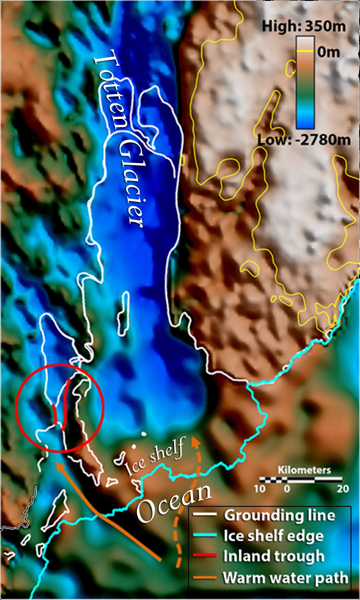
Where Totten enters the Southern Ocean, it is mostly grounded in shallows <500 meters deep. This does not affect its stability (like the Ross Ice Sheet), since the first ~500 meters of Antarctic coastal seawater is basically at the freezing point. But warmer seawater below about 500 meters is melting Totten’s base at a deep trough about 5 km wide and about 800 meters deep, discovered in 2015 [link]. This melting causes a slow retreat of the grounding line behind the trough. The annual basal melting/grounding line retreat rate is presently about 100 meters/year, (but as fast as 175 meters per year in some places according to Aitken per WaPo). It is useful to note that Aitken was an author, but not lead author, on the 2015 trough discovery paper.
This deep ocean melting process could move inland for about 150 km through the Sabrina subglacial basin (deep blue in the following figure from the 2015 paper) over about 1500 years before hitting a sub-ice rock ridge perpendicular to the glacier only about 200 meters below sea level, which would stop the melting (since melting water is below ~500 meters). Aitken et. al. 2016 estimate that this would raise sea level about 0.9 meters, or ~6 cm/century. No cause for alarm.
What Aitken et. al. 2016 reports is another fjord like deep ‘fault trench’ through this blocking ridge, which would (if water temperature stratification remained undisturbed) enable basal melting to proceed through the interior Aurora subglacial basin behind the ridge. This process would continue for about another 350 km, or about 40% back into the Totten catchment basin. Aitken et. al. also used ice-penetrating radar to probe both the Sabrina and Aurora basin floors to confirm that Totten did in fact melt back through both basins about 3 million years ago in the Pliocene (before the onset of the current ice ages), with CO2 at about 400 ppm. That was spun into the PR alarm—it happened before at 400 ppm!!! At the current melting rates this would take about 3 millennia and could raise sea level about 2.9 meters, an unalarming 10cm/century. This is probably still far too fast, since all the Aurora warming water would have to enter undisturbed through the newly reported narrow trench through the ridge.
This is NOT fundamentally unstable collapse, implying 2-3 meters SLR by the end of this century, as the authors clearly intimated in their press releases.
How to get 3 feet of SLR by melting the Sabrina basin back to the ridge? Simply assume that all the ice in the catchment basin to the ridge disappears, even that above sea level not subject to seawater melting. To the ridge and ‘trench’, the catchment basin is about 200-250 km wide, the glacier about 100 km wide, its mouth and protruding ice shelf 145 km wide. The assumption is dubious, but not implausible. It would imply ice flow similar to that of coastal northeast Greenland glaciers today (another overhyped SLR alarm favorite), except where there are no such flowing glaciers today, and where Antarctica never gets above freezing in summer (while most of Greenland does, briefly).
How to get 2.9 meters SLR from the red oval? Easy. Just use the same entire catchment assumption to that deeper recessional melting point.
How to get ~4 meters (WaPo)? Just assume that if the Aurora basin behind the ridge melts via trough/trench intrusion of warmer seawater, the entire catchment will then lose all its ice because it lost its Totten ‘plug’ (up catchment ice is about 2.5 km thick).
This is the same assumption Rignot made in raising PIG alarm about losing all the ice in the Amundsen Embayment catchment, even though his own paper showed that is impossible (as per my previous post at CE).
This is the same assumption that the Greenbaum et. al 2015 trench paper cited above made (on which Aitken was a co-author), upon which Aitken et. al. 2016 builds. From its SI,
8. Sea Level Potential for Totten Glacier and the Aurora Subglacial Basin
We estimate the global sea level potential of ice flowing through Totten Glacier using a modified approach applied for Thwaites and Pine Island Glaciers. We find the ice volume within the Totten Glacier Catchment20, correct for the higher density of seawater, subtract the volume of seawater required to replace the submarine ice, and divide the result by the area of the world oceans (3.6E14 m2). The result, ~3.5 meters, is conservative because it implies vertical catchment boundaries whereas, in reality, ice from neighboring catchments would contribute to the total sea level contribution if the entire catchment was drained of ice.
We follow a similar procedure to compute the total potential global sea level contribution of the Aurora Subglacial Basin (ASB) using catchment 13 defined on NASA Goddard Space Flight Center’s drainage basin website21. Using that catchment we find that at least 5.1 m of global sea level potential is grounded below sea level and is therefore more susceptible to retreat. This figure assumes that all remaining ice grounded above sea level remains as it is today with unrealistic vertical cliffs. If all of the ice in the ASB were to melt, the total sea level contribution would be closer to 6.7 meters. The sea level figures here have not been corrected for isostatic rebound associated with the removal of ice loading of the crust.
[Note: the 6.7 meters assumes all the ice in this entire sector of the first figure disappears. It is easy to build scary PR from bad assumptions. Rignot blazed a false trail now relied on [SI fn 17, 18] by others.
Conclusion
The alarming estimates from this new Nature paper, particularly as represented by the media, are grievously wrong both with respect to the amount of and the rate of sea level rise that might be associated with melting of the EIAS Totten glacier.
There is unjustified author spin in the press releases and author’s interviews. There are underlying bad assumptions never mentioned except by reference to a previously refuted [here] bad paper by Rignot. A tangled web of deceit, to paraphrase a famous poem.
Regards to all CE denizens.
Postscript. Since JC justifiably demanded and has received edited precision from an earlier first draft guest post on most of the above, the final paraphrase is exactly to Sir Walter Scott’s Marmion (1808) concerning the Battle of Flodden. Canto VI, XVII:
‘Oh what a tangled web we weave,
When we first practice to deceive!’
JC note: As with all guest post, please keep your comments civil and relevant.Filed under: Polar regions