by Judith Curry
The 12 year drought of major hurricane landfalls in the U.S. is over, with catastrophic impacts in Texas. Predictions of Hurricane Harvey illustrate the realization of extended- and long-range hurricane forecasts.
This blog post analyzes the forecasts of Hurricane Harvey made by my company Climate Forecast Applications Network (CFAN), and also by the National Hurricane Center.
The models included in this analysis are:
- ECMWF: 15 day HRES and ENS, and monthly (ENS extended)
- NOAA: 15 day GFS and GEFS
- NHC: HWRF, HMON
- CFAN: calibrated tracks and intensities for ECMWF and NOAA models
The images of tracks and intensities from the NOAA GEFS and ECMWF shown here are CFAN’s calibrated tracks and intensities. For further information about CFAN’s tropical cyclone forecast products and methods, see [link].
Hurricane Harvey – overview
An extensive summary Hurricane Harvey is provided by the Wikipedia:
Hurricane Harvey is a currently active tropical cyclone that recently made landfall in the US state of Texas as a Category 4 hurricane. It is the first major hurricane to make landfall in the United States since Wilma in 2005, ending a record 12-year period with no storms making landfall in the U.S. as a major hurricane.
Harvey developed from a tropical wave to the east of the Lesser Antilles on August 17. Upon entering the Caribbean Sea, Harvey began to weaken due to moderate wind shear and degenerated into a tropical wave early on August 19. [Harvey redeveloped] over the Bay of Campeche on August 23. Harvey then began to rapidly intensify on August 24, re-gaining tropical storm status and becoming a hurricane later that day. Harvey’s intensification phase stalled slightly overnight from August 24–25, however Harvey soon resumed strengthening and became a Category 4 hurricane late on August 25. Hours later, Harvey made landfall near Rockport, Texas, at peak intensity.
The story of Hurricane Harvey is not yet over, as it continues to produce catastrophic rainfall in Texas and seems likely to re-enter the Gulf for some intensification and 2nd landfall in Texas or Louisiana.
Genesis of Harvey
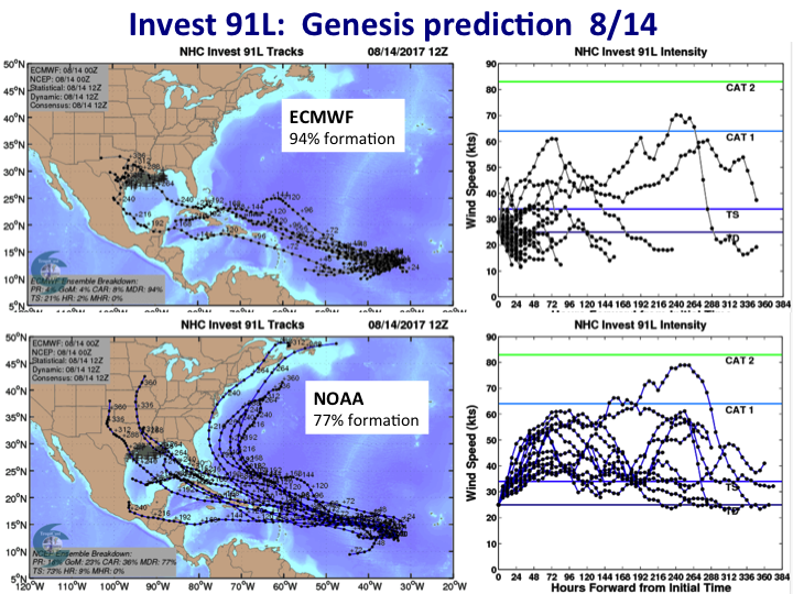
On Aug 13, we saw the first hints of storm that would become Harvey, as both the NOAA and ECMWF spotted an African Easterly Wave with the possibility of developing. The NHC issued an Invest on Aug 13.
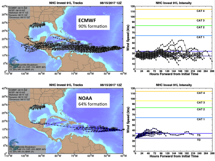
On 8/15, both ECMWF and NOAA settled into a westerly track towards Central America
Harvey became a named tropical storm on 8/17. Here are predicted tracks 15 hours before genesis, with ECMWF showing the first hints of tracks into Texas:
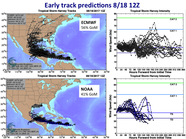
On 8/18, we see increasing probability of Harvey entering into the Gulf of Mexico: ECMWF (56%); NOAA (41%).
On 8/19, Harvey was downgraded to a tropical wave as it encountered high wind shear, north of Colombia. Both models continued to predict re-genesis, with ECMWF being somewhat more bullish than NOAA.
The NHC did not issue any advisories for the period between 03Z on 8/20 and 15Z on 8/23. However, there was significant predictability during this period.
Signs of a Texas landfall started to appear, with greater than 50% probability of a TX landfall first predicted by CFAN’s calibrated track probabilities for NOAA on 8/21 00Z and by ECMWF on 8/22 12Z:
Early intensity forecasts using CFAN’s calibrated intensities and probability distribution showed ~50% probability of a hurricane forming on 8/24
On 8/22, one day before Harvey re-formed as a tropical storm, both NOAA and ECMWF were consistently predicting a landfall in south Texas. CFAN’s calibrated GEFS tracks show high probability for the track that matched closely Harvey’s eventual track.
The NOAA GFS forecast (blue line) is used to drive two high resolution mesoscale models: HWRF and HMON. HMON is a new model (replacing GFDL), and HWRF received an upgrade for the the 2017 season. It is seen that the 8/22 track for HMON is too far south, whereas HWRF shows a similar track to the GFS. Early intensity forecasts predict Harvey to become a hurricane.
The ECMWF forecast on 8/22 predicts a track that is slightly south of the eventual landfall location. CFAN’s calibrated ECMWF tracks, relative to the raw ECMWF tracks, show a more northerly track that is closer to the eventual path and landfall location. CFAN’s dynamic cone of uncertainty is developed from our calibrated track forecast combined with a Monte Carlo resampling of historical track errors.
By the time of re-genesis on 8/23, the tracks for both models had solidified, with a landfall location north of Corpus Christi TX.
Intensity forecasts
Given the consistent track predictions among models and with time, after re-genesis on 8/23, attention turned to the intensity forecasts. On 8/24, Harvey began to rapidly intensify.
The intensity forecasts shown below include the GFS (dark blue), ECMWF HRES (red), ECMWF clustered ensemble members (black), HWRF (yellow-orange), ad HMON (green).
HWRF was the first model to pick up hints of rapid intensification, on 8/24 00Z. The first model to predict Cat 3 was GFS at 8/24 12Z. HMON was the first model to approach a Cat 4 forecast 8/25 00Z.
Closer to landfall, ECMWF DET (HRES) predicted the highest intensity (approaching Cat 4). Note, after landfall, the NOAA/NHC models predict a rapid fall off in intensity, whereas ECMWF predicts reintensification about 4 days after initial landfall. This third act for Harvey is still playing.
Summary of forecast model performance
Since Hurricane Sandy in 2012 and the exceptionally accurate forecast of ECMWF as much as 6 days in advance, there has been a battle of the hurricane forecast models: NOAA/NHC versus ECMWF. For Harvey, all of the forecast models both performed very well, albeit with some differences.
Summary of the forecasts, using CFAN’s calibrated ECMWF and NOAA GEFS forecasts:
- Harvey’s first genesis predicted by ECMWF & NOAA on 8/14, three days in advance and 12 days before landfall
- Significant probability for tracks in the GoM predicted on 8/18 by ECMWF (56%) & NOAA (41%)
- (Re)genesis: ECMWF had earlier, more consistent prediction
- >50% probability of TX landfall: ECMWF (8/22 0Z); NOAA (8/21 0Z). Edge to NOAA.
- Track forecast solidifies: NOAA 8/21 12Z; ECMWF 8/23 00Z
- Best 4 day track forecast: NOAA GFS
- Earliest prediction of Cat 3: NOAA GFS 8/24 12Z
- Earliest prediction of (near) Cat 4: HMON 8/25 00Z
Summary evaluation:
There was substantial predictability of Harvey’s track and intensity during the period 8/20-8/22, when the NHC was not issuing any Advisories.
ECMWF performed best beyond 5 days, for genesis and extended range track forecasts, whereas NOAA GEFS/GFS performed best within 4-5 days. This is consistent with the comprehensive evaluation undertaken by CFAN in 2012.
For landfall intensity, GFS, HWRF, HMON, ECMWF DET performed best at different lead times. The most surprisingly good forecast were the high resolution global model forecasts GFS and ECMWF DET.
Both the HWRF and HMON (NHC models) appear much improved relative to last years HWRF and GFDL. However, for Harvey there was not much value added by the HWRF and HMON relative to the GFS. Intensity forecasts depend on accurate track forecasts, which can a problem for the NHC models
CFAN’s calibration of ECMWF and GEFS tracks and intensity adds considerable value to the forecasts in extending the prediction horizon for tracks, providing accurate intensity forecasts from the global model ensembles, and probabilities (formation, track location, intensities). Especially for the GEFS, whose ensembles are underdisperse, CFAN’s Monte Carlo resampling provides a better representation of the uncertainty and extends the track probabilities to longer time horizons.
Harvey’s third act
At the time of this writing, Harvey’s havoc is still far from over.
ECMWF has been predicting re-entry into the Gulf of Mexico and re-intensification since 8/23 00Z (ECMWF DET HRES is red, ECMWF ensemble mean is black):
The GFS picked up on this on 8/23 18Z. Here is the latest forecast at the time of this posting, in terms of re-emergence into the Gulf. The plot show the 8/27 12Z forecast, with track positions on day 3. The intensity forecasts show some intensification (fortunately, Harvey cooled off the Gulf with wind-driven upwelling).
Long-range forecasts
Harvey was a very predictable storm, with genesis predicted 12 days in advance of landfall. Hints of Harvey’s formation had signals back to 7/24.
Twice per week, CFAN produces a monthly forecast of track density probability, using the ECMWF monthly ensemble forecasts.
In all four forecasts shown below (7/24, 7/27, 7/31, 8/03), we see elevated probability of tracks between 15-20N in the east and central Atlantic, with a bulls-eye in the Bay of Campeche. This elevated track probability is consistent with Harvey’s path.
On the 8/03 forecast, note the elevated probabilities in the Atlantic for the period 8/18 to 9/03. The circle east of Georgia/South Carolina corresponds to the likely location of Invest 92L (soon to be Irma?). The area of high probability in the central tropical atlantic, plus the two areas to the east of the U.S. may be an early harbinger of what is likely to be the next Invest.
CFAN’s latest 15 day forecast is shown below, encompassing these two storms (top is ECMWF, bottom is NOAA GEFS).
The track probability table shows that GEFS is somewhat more bullish on formation in the next two days for the storm just off the coast of Georgia. Both models have formation probabilities in the next two days exceeding 80% for the wave emerging from the coast of Africa.
Harvey in context
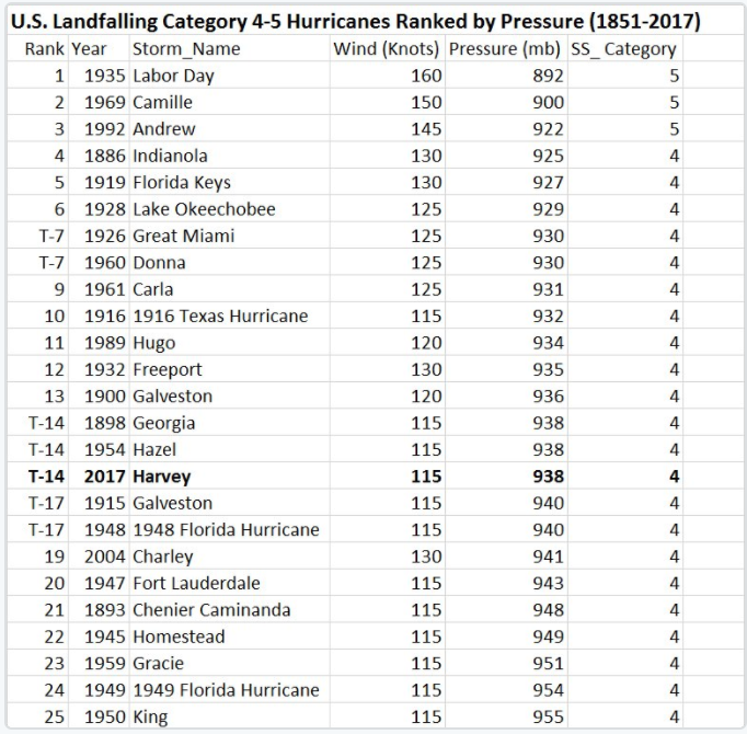
I’m sure you won’t be surprised to hear people blaming Harvey on global warming. How unusual was Harvey? Well, it will definitely be in the record books for ending the 12 year drought of major hurricanes striking the U.S.
Phil Klotzbach has prepared this list off Cat 4-5 U.S. landfalling hurricanes:
This list reminds us how awful things were. Apart from the horrendous 2004/2005 years, we have been pretty lucky in recent decades.
Anyone blaming Harvey on global warming doesn’t have a leg to stand on.
Harvey will be in the record books for almost unbelievable amounts of rainfall (the final tally is not in yet; unfortunately it will still be raining in TX for several more days, with potential doubling of the amount that has already fallen). While there was a large amount of water vapor ingested into Harvey, the huge amounts of rain are associated with Harvey’s stalled movement, while still close enough to the Gulf to continue to suck in moisture.
JC reflections
Continued improvements to the global forecast models (e.g. ECMWF, NOAA GFS/GEFS) and to the mesoscale hurricane models are increasing the accuracy of hurricane forecasts at longer time horizons.
The challenge is to appropriately interpret these long-range forecasts in context of the uncertainties. CFAN has been making extended- and long-range hurricane forecasts since 2007. The value add from CFAN’s tropical cyclone forecasts includes:
- proprietary tracking algorithm
- calibration of tracks and intensities using historical track errors with the model reforecasts
- probability forecasts of tropical cyclone genesis (formation)
- dynamic cone of track uncertainty, derived from Monte Carlo resampling from the model hindmost track error distribution
This year the NHC is calling earlier Invests, which I think is a good thing. The prospects for extended- and long-range hurricane forecasts is pretty much being realized; the challenge is forecast interpretation and uncertainty assessment.
Apart from longer range considerations of genesis forecasts, the NHC seems focus on the 5 day forecasts from its mesoscale models. Because they are driven by a single realization of the global forecast model, substantial errors can result if this single realization has large scale dynamics and a track that are in error. You really need to work with an ensemble of forecasts. Investing so much NHC resources in models like the HWRF and HMON won’t help if the GFS forecast is off. While the GFS forecast performed well for Harvey on the shorter timescales, tracks for both HWRF and HMON were often off target, which led to intensity forecasts that were either not very good, or good for the wrong reasons.
The real battle of the hurricane forecast models is shifting to the global ensemble forecast models (e.g. NOAA GEFS and ECMWF) versus the mesoscale models (e.g. HWRF, HMON).
While the 5 day NHC forecasts are sufficient for evacuation purposes, forecasts out to 7 or 8 days help support emergency management such as stocking retail stores (think Home Depot), crew mobilizations for electric power restorations and debris clean up, etc. There are general business continuity issues that benefit from early forecasts (including making inland hotel reservations). When a hurricane strikes the ‘oil patch’ in the Gulf of Mexico, production is shut down and potentially the refineries. Prices at the gas pump are already going up.
And of the course the reinsurance, financial and energy trading sectors want as much forecast leadtime as possible.
While most of the hurricane forecast effort has been for winds (including storm surge), Harvey emphasizes that rainfall predictions are equally important, particularly when landfall involves a city with relatively impervious surfaces (for which Houston is a poster child). The global models have done a good job predicting rainfall. CFAN will begin making rainfall forecasts for hurricanes in 2018.
Bottom line: no one should have been surprised by Harvey, which had exceptionally accurate forecasts as far back as 8/23. The Texas Hurricane Preparedness Coordinator, John Honore, the National Weather Service and the media have done an excellent job of warning. Even after Harvey reached category 4 and with predictions for massive amounts of rain, it seems almost unbelievable that this could happen.
Stay safe.