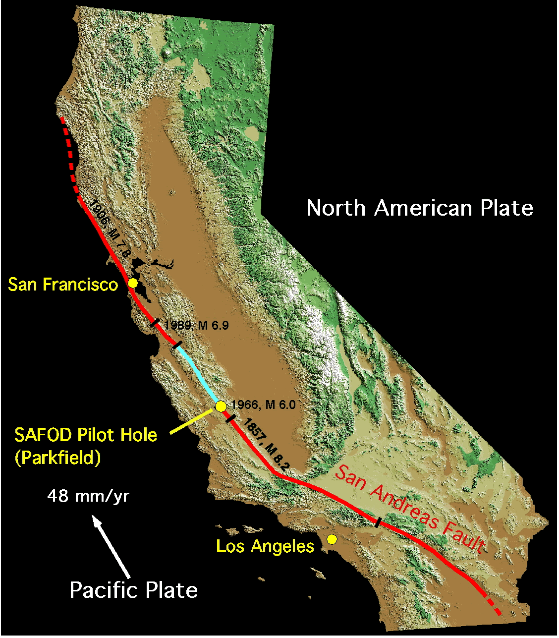
An earthquake preparedness film produced in Victoria, British Columbia (source)by Gaius PubliusThis is not quite a political story, but it's an important one. Most people west of the Mississippi and many people east of it assume that the so-called "Big One," the mother of all American earthquakes, will occur in southern California along the San Andreas fault.Shaded relief map of California showing the location of SAFOD [San Andreas Fault Observatory at Depth]. Major historical earthquakes along the San Andreas Fault are shown, with the creeping section of the fault in blue. (© USGS, click to enlarge) [source]But scientists who study plate tectonics have come to a surprising, and relatively recent, conclusion — the "big one" is more likely to come in the Pacific Northwest, and it's likely to be the "really big one." I can only give you a small part of this excellent recent article in the New Yorker by Kathryn Schultz, but if this interests you at all, the piece is worth reading through. There's both good science and important warning here. And if you're a resident of the region, it may qualify as a must-read. The problem in a nutshell, from just after the start of the article (my emphasis):
Most people in the United States know just one fault line by name: the San Andreas, which runs nearly the length of California and is perpetually rumored to be on the verge of unleashing “the big one.” That rumor is misleading, no matter what the San Andreas ever does. Every fault line has an upper limit to its potency, determined by its length and width, and by how far it can slip. For the San Andreas, one of the most extensively studied and best understood fault lines in the world, that upper limit is roughly an 8.2—a powerful earthquake, but, because the Richter scale is logarithmic, only six per cent as strong as the 2011 event in Japan.Just north of the San Andreas, however, lies another fault line. Known as the Cascadia subduction zone, it runs for seven hundred miles off the coast of the Pacific Northwest, beginning near Cape Mendocino, California, continuing along Oregon and Washington, and terminating around Vancouver Island, Canada. The “Cascadia” part of its name comes from the Cascade Range, a chain of volcanic mountains that follow the same course a hundred or so miles inland. The “subduction zone” part refers to a region of the planet where one tectonic plate is sliding underneath (subducting) another. Tectonic plates are those slabs of mantle and crust that, in their epochs-long drift, rearrange the earth’s continents and oceans. Most of the time, their movement is slow, harmless, and all but undetectable. Occasionally, at the borders where they meet, it is not.Take your hands and hold them palms down, middle fingertips touching. Your right hand represents the North American tectonic plate, which bears on its back, among other things, our entire continent, from One World Trade Center to the Space Needle, in Seattle. Your left hand represents an oceanic plate called Juan de Fuca, ninety thousand square miles in size. The place where they meet is the Cascadia subduction zone. Now slide your left hand under your right one. That is what the Juan de Fuca plate is doing: slipping steadily beneath North America. When you try it, your right hand will slide up your left arm, as if you were pushing up your sleeve. That is what North America is not doing. It is stuck, wedged tight against the surface of the other plate.Without moving your hands, curl your right knuckles up, so that they point toward the ceiling. Under pressure from Juan de Fuca, the stuck edge of North America is bulging upward and compressing eastward, at the rate of, respectively, three to four millimetres and thirty to forty millimetres a year. It can do so for quite some time, because, as continent stuff goes, it is young, made of rock that is still relatively elastic. (Rocks, like us, get stiffer as they age.) But it cannot do so indefinitely. There is a backstop—the craton, that ancient unbudgeable mass at the center of the continent—and, sooner or later, North America will rebound like a spring. If, on that occasion, only the southern part of the Cascadia subduction zone gives way—your first two fingers, say—the magnitude of the resulting quake will be somewhere between 8.0 and 8.6. That’s the big one. If the entire zone gives way at once, an event that seismologists call a full-margin rupture, the magnitude will be somewhere between 8.7 and 9.2. That’s the very big one.Flick your right fingers outward, forcefully, so that your hand flattens back down again. When the next very big earthquake hits, the northwest edge of the continent, from California to Canada and the continental shelf to the Cascades, will drop by as much as six feet and rebound thirty to a hundred feet to the west—losing, within minutes, all the elevation and compression it has gained over centuries. Some of that shift will take place beneath the ocean, displacing a colossal quantity of seawater. (Watch what your fingertips do when you flatten your hand.) The water will surge upward into a huge hill, then promptly collapse. One side will rush west, toward Japan. The other side will rush east, in a seven-hundred-mile liquid wall that will reach the Northwest coast, on average, fifteen minutes after the earthquake begins. By the time the shaking has ceased and the tsunami has receded, the region will be unrecognizable. Kenneth Murphy, who directs FEMA’s Region X, the division responsible for Oregon, Washington, Idaho, and Alaska, says, “Our operating assumption is that everything west of Interstate 5 will be toast.”.
I've bolded the parts that describe the geologic stress and what's likely to happen to the land when it releases. The upward bulge of the land includes the Cascades mountain region and land west to the sea (Mount Hood, in the Cascades Mountains, is only 80 miles east of Portland). A six-foot drop in elevation of land within "a few minutes" would destroy everything built on top of it. A similar drop beneath the ocean would create a tsunami that would wipe out everything living along the coast.Here's a picture:The northern part of the Cascadia Subduction Zone (click to enlarge; source)Here's another, showing the extent of the affected area:As the source states, "Subdiction of the Juan de Fuca plate beneath the North American plate results in the formation of the Cascade Range." Click to enlarge.And another showing the elevations:Portland sits between the Oregon Coast Range and the Cascade Range (click to enlarge; source).If a full rupture occurs, the impact will be devastating: "that region will suffer the worst natural disaster in the history of North America," writes Schultz.
Roughly three thousand people died in San Francisco’s 1906 earthquake. Almost two thousand died in Hurricane Katrina. Almost three hundred died in Hurricane Sandy. FEMA projects that nearly thirteen thousand people will die in the Cascadia earthquake and tsunami. Another twenty-seven thousand will be injured, and the agency expects that it will need to provide shelter for a million displaced people, and food and water for another two and a half million. “This is one time that I’m hoping all the science is wrong, and it won’t happen for another thousand years,” Murphy says.
Devastation aside, the science on this is fascinating. Schultz writes, "Thirty years ago, no one knew that the Cascadia subduction zone had ever produced a major earthquake. Forty-five years ago, no one even knew it existed." If you want to skip to that part, find the sentence that starts, "Almost all of the world’s most powerful earthquakes occur in the Ring of Fire" and continue from there. The study of the "ghost forest" on the banks of the Copalis River and the tale it told to alert researchers makes terrific reading. There's much more here than I can quote comfortably — the detective work that revealed the date of the last "really big one" ("approximately nine o’ clock at night on January 26, 1700"); the lack of preparation, and the cost of preparing properly to respond to an emergency of this scale.FEMA, Disaster Preparation and Our Billionaires Which is where I want to add a word of my own. Funding FEMA, of course, to an adequate level is a first priority. Yet we live in a time of pathological billionaires, rulers of both parties, who don't want to spend the first spare dime on any class of people but their own. The arrogance of this class, from Donald Trump to Sheldon Adelson to Jamie Dimon, is astounding — I may have some comparison video shortly. Left or right, they're mainly all the same. If you watched the Trump vs. Ramos video, you watched them all in action. As with their arrogance, so their self-dealing. Americans are forced to use increasingly service-cutting, space-cutting airlines for long-distance travel because "our betters" say they can't afford to raise Amtrak to anything close to European standards. (Have you ridden an American passenger train lately along any but the DC–New England corridor?) Yet here's how the very very rich take to the air, financed, if they can get it, by corporate tax loopholes and compensation extras. If they "can't afford" to give us good trains, bridges, or roadways, how will this class ever allow us to prepare for an emergency on the scale described here?We seem to be stuck, until we don't want to be. Talk about a tectonic subduction zone — that we continue to be ruled by the global rich is a "sticking point" of monstrous proportions. The pressure, on them and on us, to keep things as they are is enormous. I'm afraid the consequences — political, social, environmental, climatological — of coming "unstuck" from our own ruling class will be monstrous as well.I guess this was a political story after all.GP