Did you spot the contradiction in the headline? Hot Air can't Leave me Cold.And "global warming" can't be the cause of record cold and snow in the fall/autumn. As we bask in January like temperatures here, with 30 cms/ 12 inches of snow just outside, the question is ... where's the warming?- Cold being the absence of heat and it's unusually abnormally cold. And global warming, aka AGW, aka human caused carbon warming, cannot bring the cold. That's just spin for the gullible.Weather Network
Tuesday, November 12th 2019, 8:20 pm - Frigid air descends on southern Ontario ahead of the next shot of snow.The record-breaking early November snow has moved on, but the record-breaking cold is just taking hold over southern Ontario. A blast of Arctic air will see temperatures plunge into the minus teens for some with wind chill values hitting -20 before dawn on Wednesday. The brisk north-northwest winds responsible will also spur continuing lake-effect streamers for some -- and that's ahead of the next widespread snowy system set to move in on Wednesday night. We look at where travel will still be tricky, and how long the bitter cold lasts, below.
Recorded temperature at this moment is -15 C or 6 F ( 6: 15 am est)Seasonal norms for this time would be a low of 2C or 34 F. Instead we're sitting at minus 15C. That's a big temperature difference. Large deviation from seasonal norms..Where's that warming?UPDATE 5:00 pm est Nov. 13/19 Hamilton and Niagara break records for snow and cold in winter ( FALL, it's FALL) welcome
According to Phillips, Hamilton had never seen a snowier Remembrance Day. The last snowfall record for Nov. 11 was set in 1983 with just 8.6 cm of snow.
Phillips said that Hamilton International Airport recorded 17 cm of snow, while the St. Catharines area and Grimsby got even more, with places receiving anywhere from 20 to 25 cm of snowfall.
"The closer you were to the United States, the more snow you got," he said. "[You would be] closer to the centre of the storm."
Frigid Nov. 12
And with the snow came the cold. As the storm moved away, Phillips said, it ushered in the colder, Arctic air behind it. It was brutally cold on Tuesday as people experienced temperatures that Phillips says are normally expected in the worst parts of winter. Environment Canada recorded a low of -14.1 C on Tuesday, which smashed the previous record of -7 C. Cold
Toronto Under Extreme Cold Alert as Temps Drop Significantly Overnight
The city’s chief medical officer has issued an extreme cold weather alert as temperatures are expected to drop significantly Tuesday night. According to Environment Canada, temperatures should drop to -17 C with windchill late Tuesday evening into early Wednesday morning.Temperatures are supposed to rise to -4 C by Wednesday afternoon.The alert will be in effect “until further notice,” the city said.Typically, the city issues an extreme weather alert when Environment and Climate Change Canada forecast a temperature of -15 C or colder, or a windchill of -20 C or colder.
“Exposure to cold weather can be harmful to your health. Hypothermia occurs when the body’s core temperature drops below 35 degrees Celsius and can have severe consequences, including organ failure and death. Frostbite can also occur in cold weather when skin freezes and, in severe cases, can lead to amputation when deeper tissues freeze,” the city warned in a statement. The city is opening a warming centre at Metro Hall......
RECORD-BREAKING COLD TEMPERATURES
Even if your area escapes the snow on Wednesday morning, it won't escape the cold. Frigid low temperatures more reminiscent of mid-January are expected to smash records early Wednesday, as temperatures dip into the minus teens for much of southern Ontario. Bitter wind chill will make heading outside Wednesday morning even more unpleasant.
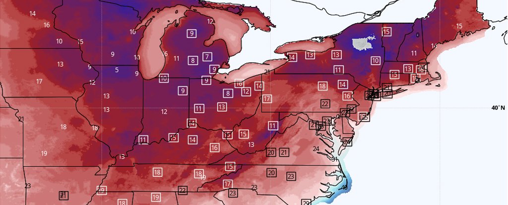
My American friends are chillin' as well- Arctic Blast ya know?Forecast low temperatures for Wednesday.
A surge of frigid air is barreling across the eastern half of the nation, unleashing snow and, in many locations, the coldest weather on record for this time of year.The National Weather Service is calling it "the coldest surge of arctic air so far this season," predicting 385 cold records to fall from the Plains to the East Coast through Wednesday.In many locations, temperatures have bottomed out or will drop to 15 to 30 degrees Fahrenheit below average. For tens of millions, the cold will barge in suddenly, with temperatures plummeting 30 degrees F in 12 hours or less.In Dallas, the temperature crashed 19 degrees F in a single hour Monday as the Arctic front moved through, from 65 to 46 F (18 to 7 degrees Celsius) between 10 am and 11 am local time, as winds gusted to 44 mph (70 km/h). Lows are predicted to drop into the 20s there on Monday night.
The cold first invaded the northern Rockies on Sunday. In Havre, Mont., the mercury tanked to a record low of -18 F (-27 C) on Sunday. Then, on Monday, temperatures in northern Montana fell as low as -30 F (-34 C).The cold is rapidly expanding southeast and will even reach the zone from Galveston, Texas, to the Florida Panhandle along the Gulf Coast. By Wednesday morning, almost the entirety of the eastern half of the Lower 48 will see freezing temperatures, except for the Florida Peninsula.
How's the UK faring? UK weather forecast: Snow to slam Britain after -9C night - will it hit near you?
Britain is set to be slammed by up to 10cm of snow after temperatures plunge as low as -9C on the coldest night of autumn so far.This week has brought the first cold snap of the season, with temperatures several degrees below normal, and nasty weather conditions are expected from Tuesday.
Cold is the absence of heat. Clearly the planet is not on fire. Can we stop with this nonsense already?