by Judith Curry and Jim Johnstone
CFAN predicts an active North Atlantic hurricane season season.
The Atlantic hurricane has begun. We are off to an early start with one wimpy subtropical storm that lasted less than a day, and a small system that is trying to spin up in the Bay of Campeche.
Other forecast providers have begun issuing forecasts:
- NOAA predicts a near normal season with 4-8 hurricanes.
- Tropical Storm Risk predicts slightly below normal activity, with 6 hurricanes and ACE of 88.
- Colorado State University predicts near normal season: 6 hurricanes and ACE of 100
Climate Forecast Applications Network (CFAN) is going bold, see below. [link] to forecast report.
CFAN’s seasonal forecast
Table 1. Current (May) 2019 hurricane forecasts of North Atlantic ACE, North Atlantic total hurricanes, U.S. landfalling hurricanes.
Introduction
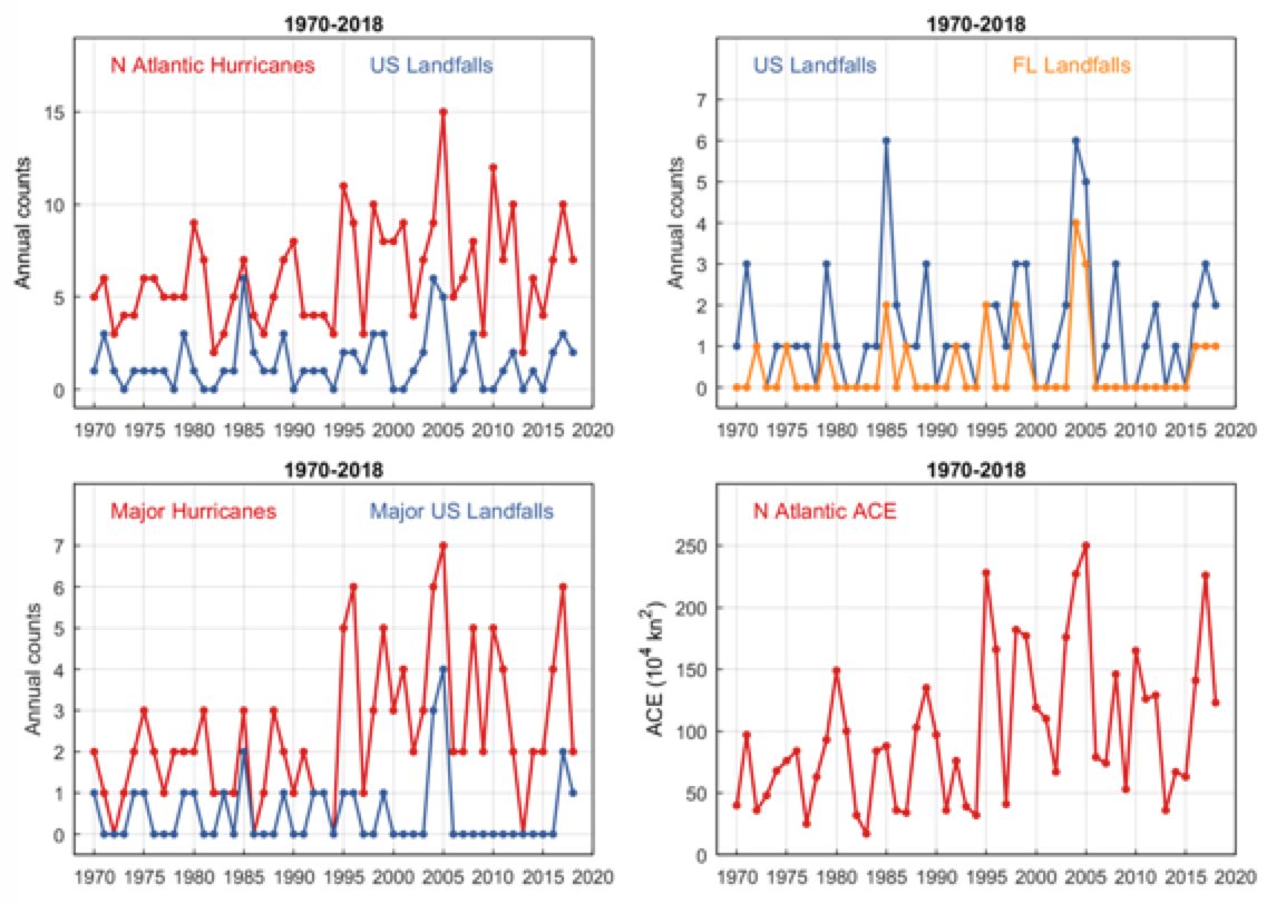
Indices of North Atlantic hurricane activity display substantial interannual variations (Fig. 1), in addition to prominent multidecadal changes that are positively associated with basin-scale sea surface temperature (SST) changes known as the Atlantic Multidecadal Oscillation (AMO). North Atlantic Accumulated Cyclone Energy (ACE), an integrative metric based on tropical cyclone wind speeds, approximately doubled with an abrupt 1995 shift toward warmer North Atlantic surface conditions.
Figure 1. North Atlantic hurricane indices, 1970-2018. Top: North Atlantic hurricane totals (red) and U.S. landfalls (blue). Center: Major hurricanes and U.S. landfalls. Bottom: North Atlantic Accumulated Cyclone Energy (ACE). Hurricanes, major hurricanes, and ACE increased abruptly in 1995 with a shift toward higher North Atlantic sea surface temperatures associated with the Atlantic Multidecadal Oscillation.
CFAN develops seasonal to annual climate forecasts using an innovative data mining approach guided by climate dynamics analysis. CFAN’s late-May seasonal forecast for the 2019 Atlantic hurricane season is based on climate conditions and tendencies observed in data from January 1 through May 17, 2019.
Recent climate anomalies and ENSO update
Overall, there is little change relative to CFAN’s ENSO forecast report in March 2019, although there is growing support for an El Niño Modoki in autumn. Expected summer sea surface temperature (SST) conditions in the tropical Pacific were assessed in CFAN’s March 2019 ENSO forecast. CFAN’s March ENSO forecast called for weakening eastern Pacific El Niño conditions during spring but a partial regrowth of central Pacific El Niño Modoki warmth during July-August-September (JAS), overlapping with the early part of the hurricane season. Forecasts suggest largely neutral anomalies of North Atlantic Arc SSTs.
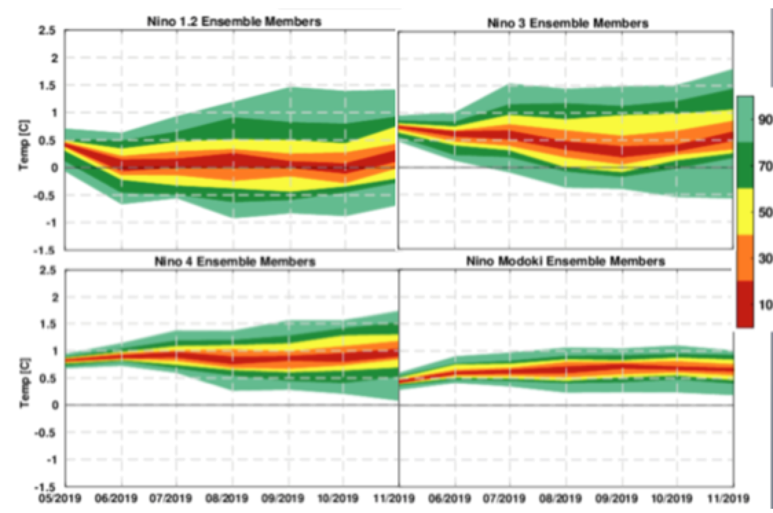
CFAN’s ENSO forecast plumes from ECMWF (initialized March 1) are shown in Figure 2, for Niño1.2, Niño 3, Niño4, and the Modoki Index. ECMWF shows a continued decline of Niño 3 and Niño 1.2 through fall. Niño 4 and Modoki values increase through mid-summer, with moderate Modoki conditions through fall. NOTE: ECMWF’s June seasonal forecast will be available June 5 (tomorrow evening).
Figure 3: CFAN’s analysis of ENSO forecasts from ECMWF seasonal forecast system (SEAS5), initialized 5/1/19.
Hurricane Predictors
CFAN’s forecast method identifies precursors of Atlantic hurricane activity from seasonal patterns of anomalies and tendencies in globally-gridded sea surface temperatures (SSTs) and numerous dynamical and thermodynamic variables based on NCEP-NCAR Reanalysis data at 17 tropospheric and stratospheric levels. While simple patterns of spring-summer climate anomalies offer direct indications of expected hurricane activity, predictions at longer leads involve interactions of slow seasonal to interannual climate processes, including those related to ENSO and the Quasi-biennial Oscillation (QBO) of equatorial stratospheric winds, which tend to undergo rapid phase transitions during spring.
The actual predictors used are not described in the publicly-issued forecast report; more details are provided to our clients.
Forecast models
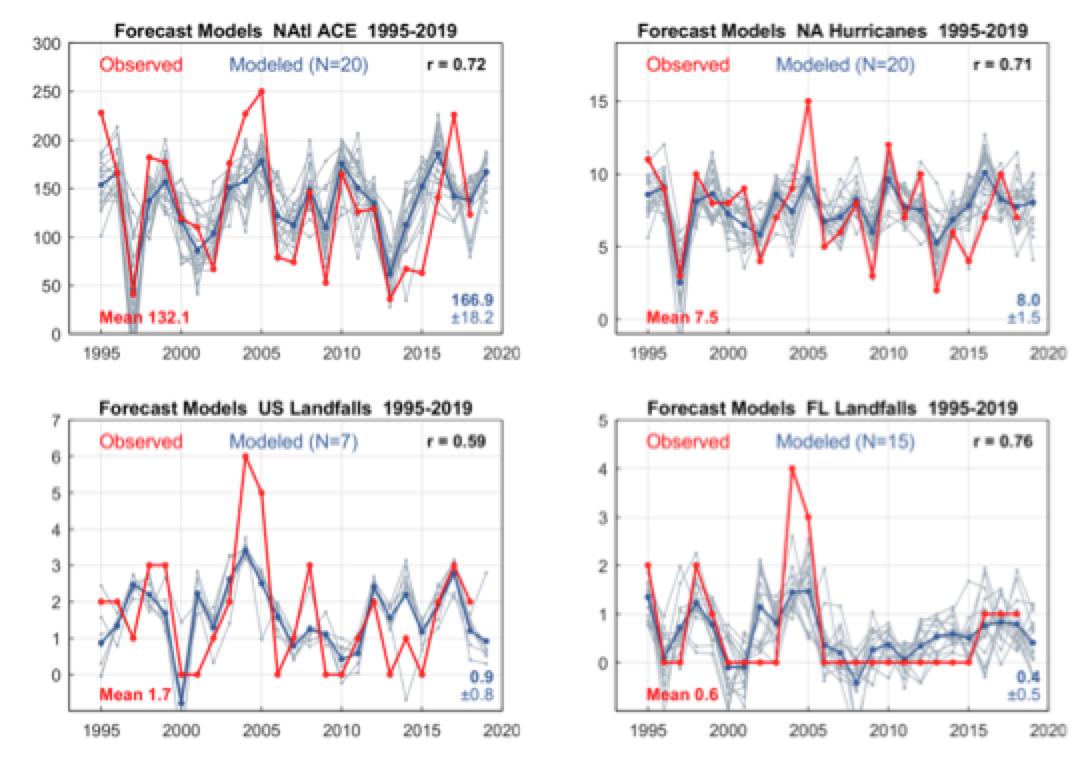
Figure 5 illustrates the historical leave-one-out forecasts by the most skillful models (gray lines), and overall annual forecast values (blue lines) based on the ensemble means. Forecast model results are shown in Table 1 and Figure 5. In Table 1, forecast uncertainty is reflected in the range of model predictions, and the mean absolute error (MAE) in leave-one-out tests.
Figure 5. Model hindcast hurricane estimates (blue) and observed historical metrics (red). Fine gray lines depict individual model estimates and blue lines reflect model means. A. North Atlantic ACE. B. North Atlantic hurricane totals. C. US hurricane landfalls. D. Florida hurricane landfalls. Values in the lower right of each panel reflect the expected 2019 index value based on the mean of individual model estimates and the ±1 standard deviation spread. Lower left values display index means over the 1995-2018 period.
Potential 2017 analogue
Our forecast issued in November 2018 suggested above-average hurricane activity in 2019, reflected by ACE forecast of 163 (1995-2018 mean: 132). High activity in 2019 was further suggested by Atlantic-sector atmospheric patterns in August-October (ASO) 2018 that closely matched those of ASO 2016, which preceded by one year the high-activity season of 2017 (ACE 226).
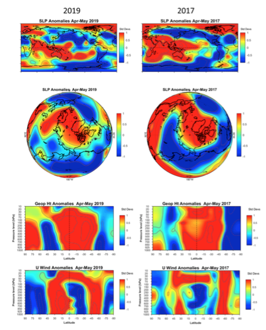
Currently, we find additional indications of atmospheric behavior that suggest a potential replay of 2017 conditions in 2019. Figure 6 compares 2019 (left) and 2017 (right) anomalies of global sea level pressure (SLP) (1st row, spatial correlation r = 0.5), NH SLP (2nd row, r = 0.5) and zonal-mean geopotential heights (3rd row, r = 0.7) and zonal (westerly) winds (4th row, r = 0.4).
Figure 6. Comparison of April-May atmospheric anomalies during 2019 (left) and 2017 (right), based on data from April 1-May 17. Top row: Global sea level pressure (SLP). 2nd row: NH SLP. 3rd row: Zonal-mean geopotential heights, by latitude (x-axis) and height (y-axis). 4th row: Zonal-mean U (westerly) winds.
Global April-May SLP anomalies during both years (Fig.6, 1st row) feature a wide zone of high pressure over the tropical Indo-Pacific and an Arctic high centered over Iceland-Greenland, while negative SLP anomalies prevail over a midlatitude band stretching from western Asia to the North Atlantic. In the Southern Hemisphere, similarly-structured zones of negative SLP anomalies cover most of the Antarctic and South America.
A polar perspective (Fig. 6, 2nd row) also highlights the similar NH SLP anomaly structures during 2017 and 2019, including a Greenland high that extends southward over Europe and the Indian Ocean. Zonal-mean (east-west) anomalies of geopotential heights (Fig. 6, 3rd row) share coherent positive anomalies from the surface to the 20 hPa pressure level in the tropical-subtropical lower stratosphere, in contrast to negative height anomalies over the NH midlatitudes and Antarctica. Zonal wind anomalies (Fig. 6, 4th row) display coherent positive (westerly) anomalies involving all vertical levels from 1000 to 10 hPa around 30°N and 50°S, while anomalous easterly flow is seen at tropospheric levels (1000 to 200 hPa) in the Southern Hemisphere around 15°S. Similar states of the stratospheric Quasi-biennial Oscillation (QBO) are indicated by positive zonal wind anomalies from 20 to 70 hPa during April-May 2017 and 2019. April-May patterns generally indicate strong vertical coupling of tropospheric and stratospheric pressure and circulation anomalies in spring 2017 and 2019.
Disparities between 2017 and 2019 conditions include a recent zone of low pressure in the tropical NE Pacific during April-May 2019 (not present in 2017) that is associated with the stronger April 2019 El Niño conditions relative to 2017. Strong hurricane activity in 2017 followed an unusually rapid early-summer transition toward La Niña conditions. Our retrospective analysis of the 2017 hurricane season identified additional factors as well, including pronounced southerly flows of low-level winds and moisture toward the Gulf of Mexico from south of the equator, part of a ‘meridional mode’ (north-south) pattern involving tropical ocean-atmosphere anomalies in both hemispheres.
Discussion
Relative to average Atlantic tropical cyclone activity since 1995, our current forecasts call for above normal North Atlantic ACE and near normal North Atlantic hurricane frequency in 2019. These estimates are similar to our November forecasts, but somewhat higher than our March forecasts that were largely neutral relative to the mean activity since 1995 due to a prevalence of conflicting positive and negative indicators.
Recent indicators of high activity feature many related Arctic circulation anomalies related to positive SLP and geopotential height anomalies over the North Pole from April 1 to May 17. Arctic hurricane precursors are generally most robust during the yet-completed April-June window, and warrant close ongoing attention.
Forecast estimates of U.S. landfalls are close to 1995-2018 averages and have greater forecast uncertainties than North Atlantic ACE and hurricane totals. We will issue a late-June follow-up report on developing conditions relevant to all hurricane metrics discussed here, with a particular emphasis on those relevant to U.S. and Florida hurricane landfalls.
JC remarks
Forecasts in late May are driven by the needs of the reinsurance industry. Circulation patterns of relevance to Atlantic hurricanes generally are in place by the end of June. In a few months, we will know which forecasting group has read the tea leaves correctly.
This is one forecast where I hope we are wrong; we really don’t need another active hurricane season. The key issue of importance is landfalls; we won’t have a good reading on that until the end of June.